Lake Effect Snow: The Science Behind One of the Great Lakes' Most Fascinating Phenomena
Explore what causes lake effect snow, where it happens, how it forms, and why it's one of winter's most misunderstood weather events.
Table of Contents
-
Introduction to Lake Effect Snow
-
What Is Lake Effect Snow?
-
How Lake Effect Snow Forms: Step-by-Step Science
-
Conditions Required for Lake Effect Snow
-
Where Does Lake Effect Snow Happen?
-
Which Great Lakes Produce the Most Lake Effect Snow?
-
Lake Effect Snow vs Other Types of Snow
-
Famous Lake Effect Snowstorms in History
-
How Climate Change Is Impacting Lake Effect Snow
-
Does Lake Effect Snow Stop When Lakes Freeze?
-
Can Lake Effect Snow Be Predicted?
-
Myths and Misconceptions About Lake Effect Snow
-
Lake Effect Snow in Michigan: A Closer Look
-
FAQs About Lake Effect Snow
-
Experience the Great Lakes in Their Warm Season: Visit Mackinac Island and The Inn at Stonecliffe
-
Final Thoughts
1. Introduction to Lake Effect Snow
Few natural phenomena are as beautiful, intense, and scientifically fascinating as lake effect snow. It's a winter weather event so localized that it can dump several feet of snow in one town while leaving a nearby community nearly untouched. It shapes life around the Great Lakes each winter and is responsible for some of the most extreme snowfall events in North American history.
In this in-depth guide, we explain exactly what lake effect snow is, how it forms, where it happens, and how it may change in the future. Whether you're a weather enthusiast, student, or traveler intrigued by Great Lakes winters, this guide provides the science and storytelling behind one of nature's most unique seasonal displays.
2. What Is Lake Effect Snow?
Lake Effect Snow Definition
Lake effect snow is a localized snowfall event that occurs when cold, dry air moves across warmer lake water, picking up moisture and heat, and then depositing that moisture as snow on the downwind shores.
Key Characteristics
-
Highly localized: affects specific snowbelt regions
-
Can drop snow at rates of 2–4 inches per hour
-
Produces narrow, intense snow bands
-
Can continue for hours or even days depending on conditions
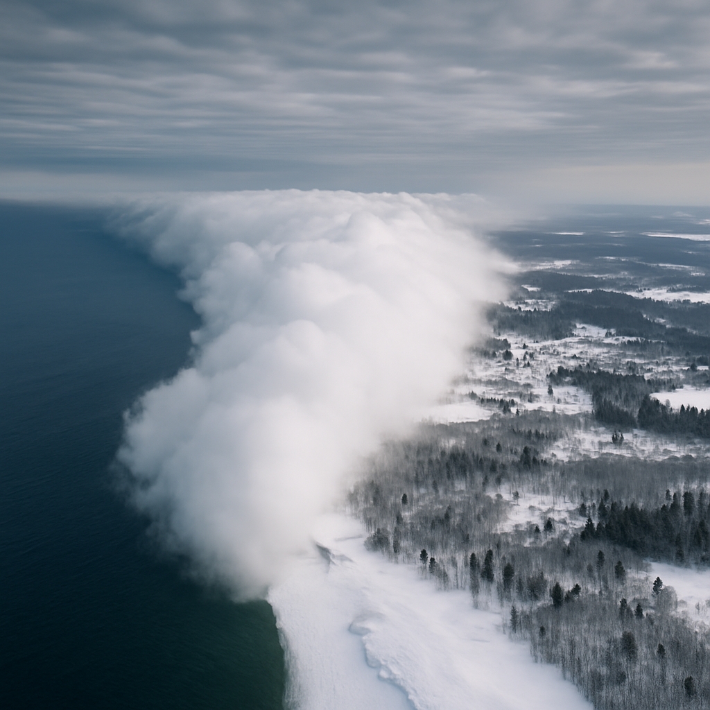
3. How Lake Effect Snow Forms: Step-by-Step Science
Step-by-Step Breakdown:
-
Cold air mass moves over the lake
-
Lake water is warmer than the air above it
-
Warm lake water evaporates, adding moisture to the air
-
The air becomes unstable, rises, and forms clouds
-
Snow falls as the air mass reaches land (downwind)
Visual Illustration (Ideal for blog use):
-
Wind arrows crossing a warm lake
-
Cloud formation over the lake
-
Snow bands targeting specific downwind areas
4. Conditions Required for Lake Effect Snow
Atmospheric Requirements
-
Cold air temperature: typically at least 13°F colder than the lake surface
-
Open water: the lake must not be frozen
-
Fetch: sufficient distance over water for the air to gain moisture (usually 60+ miles)
-
Directional wind: steady wind that aligns with the lake’s long axis
Ideal Setup
| Factor | Ideal Condition |
|---|---|
| Temperature contrast | 13°F or more |
| Wind direction | Consistent and aligned with lake orientation |
| Lake status | Unfrozen, open water |
| Air movement | Cold, dry continental polar air |
5. Where Does Lake Effect Snow Happen?
Geographic Snow Belts
| Region | Source Lake | Typical Snowfall |
| Buffalo, NY | Lake Erie | 90+ inches/year |
| Tug Hill Plateau, NY | Lake Ontario | 200+ inches/year |
| Traverse City, MI | Lake Michigan | 100+ inches/year |
| Marquette, MI | Lake Superior | 150+ inches/year |
| Erie, PA | Lake Erie | 100+ inches/year |
These areas lie downwind of the lakes, meaning cold air picks up lake moisture and dumps snow as it hits land.
Localized Impact
One town can receive 3 feet of snow while another nearby gets only a dusting, making lake effect snow highly unpredictable and localized.
6. Which Great Lakes Produce the Most Lake Effect Snow?
Lake-by-Lake Comparison
| Lake | Factors Contributing to Snowfall | Peak Snow Months |
| Lake Erie | Shallow, warms and cools quickly | November – January |
| Lake Ontario | Long fetch, cold winds from NW | December – February |
| Lake Michigan | Creates snow on both east and west shores | December – February |
| Lake Superior | Largest and deepest, longer-lasting events | December – March |
| Lake Huron | Similar to Michigan, but slightly less active | December – February |
7. Lake Effect Snow vs Other Types of Snow
| Type of Snow | Source | Coverage | Intensity | Predictability |
| Lake Effect Snow | Warm lake moisture | Localized | High | Medium |
| Frontal Snow | Large weather systems | Wide | Medium | High |
| Nor’easters | Ocean storms | Regional (East Coast) | Very High | High |
| Mountain Snow | Orographic lift | Mountain ranges | Moderate | Localized |
Key Differences:
-
Lake effect snow is much more narrow, intense, and dependent on wind
-
It’s harder to predict exact snowfall locations until the bands form
8. Famous Lake Effect Snowstorms in History
Top 3 Record Events:
-
Buffalo, NY – November 2014
-
Over 7 feet of snow in five days
-
Caused 13 deaths and shut down highways
-
-
Montague, MI – December 2016
-
Over 77 inches in 5 days
-
-
Syracuse, NY – 1993
-
Set multiple snowfall records for 24-hour accumulation
-
9. How Climate Change Is Impacting Lake Effect Snow
Observed Trends:
-
Warmer lake temperatures due to warming climate
-
Later freeze-ups mean longer lake effect seasons
-
Increased snowfall totals in early winter
Predicted Future:
-
Initially: heavier lake effect snow due to more lake evaporation
-
Later: decline in snow as lakes freeze less and winters warm overall
10. Does Lake Effect Snow Stop When Lakes Freeze?
Yes, Mostly.
Once a lake freezes over, the open water surface no longer provides heat and moisture, so lake effect snow significantly decreases.
Exceptions:
-
Partial freezing may allow some snow production
-
Larger lakes like Superior and Michigan freeze more slowly, prolonging the season
11. Can Lake Effect Snow Be Predicted?
Yes, but with limitations.
Meteorologists can predict conditions that are likely to cause lake effect snow, but specific snow band location and intensity is harder to forecast accurately.
Modern Tools:
-
Doppler radar
-
Satellite imaging
-
Wind and lake temperature sensors
12. Myths and Misconceptions About Lake Effect Snow
Myth: It only happens during big storms
Reality: Lake effect snow can occur on calm, clear days if the conditions are right.
Myth: All snowfall near the lakes is lake effect
Reality: Some snow comes from frontal systems or other weather events unrelated to lake effect.
Myth: You can always drive out of a snow band
Reality: Snow bands can shift rapidly, making driving conditions unpredictable.
13. Lake Effect Snow in Michigan: A Closer Look
Snowiest Cities in Michigan:
| City | Source Lake | Avg Snowfall (inches) |
| Marquette | Superior | 150+ |
| Traverse City | Michigan | 100+ |
| Muskegon | Michigan | 90+ |
| Petoskey | Michigan | 120+ |
Interesting Local Facts:
-
Upper Peninsula experiences intense snow squalls
-
Leelanau Peninsula gets double-digit snowfall from narrow lake bands
-
Western shorelines get hit hardest due to prevailing winds
14. FAQs About Lake Effect Snow
What causes lake effect snow?
Cold air moving over warm lake water causes moisture to rise, cool, and fall as snow downwind.
Where does lake effect snow occur most?
Around the Great Lakes, especially in Michigan, New York, Ohio, and Pennsylvania.
How is lake effect snow different from regular snow?
It’s more intense, narrow, and localized, often with rapidly shifting snow bands.
Can lake effect snow happen after lakes freeze?
Only rarely, and only if parts of the lake remain unfrozen.
Is lake effect snow getting worse with climate change?
Yes — initially. Warmer lakes lead to more snow, but over time snowfall could decrease if winters become too warm.
15. Experience the Great Lakes in Their Warm Season: Visit Mackinac Island and The Inn at Stonecliffe
While The Inn at Stonecliffe is closed during the winter months, you can still appreciate the powerful weather systems and scenic beauty of the Great Lakes during the warmer seasons from May through October.
Why Visit in Warmer Months?
-
Panoramic views of Lake Huron with peaceful sunsets
-
No lake effect snow — just blue skies and breezy lake air
-
Perfect for biking, hiking, and sailing
The Inn at Stonecliffe Highlights:
-
Historic estate tucked in nature on Mackinac Island’s West Bluff
-
Elegant rooms and suites with unmatched tranquility
-
Ideal for spring and summer getaways, weddings, and family travel
16. Final Thoughts
Lake effect snow is a natural marvel shaped by the dynamic relationship between cold air and warm lake water. From Buffalo to Traverse City, its impact can be dramatic and awe-inspiring. While it’s a winter event, its story is one that belongs to the Great Lakes year-round.
Plan your warm-weather escape to the Great Lakes region and enjoy the sights, sounds, and serenity of Mackinac Island during its most inviting months. Stay with us at The Inn at Stonecliffe — where nature, history, and hospitality come together.
Your lakeside adventure awaits — May through October.
Read other posts